

The NYC Ferry has been running since 2017 and still gets treated like a secret by a large portion of the city's population. Millions of subway riders have never stepped on one, in part because the ferry doesn't appear prominently in transit discussions and in part because its routes don't replicate what the subway does — they serve gaps in the subway network. Understanding when the ferry is useful requires knowing where those gaps are.
Explore NYC live
See the city in real time on the NYC Live Command Center — 900+ live NYCDOT traffic cameras across the five boroughs, on one screen.
Open the live dashboardHow the NYC Ferry System Works
NYC Ferry is operated under the NYC Ferry brand through the city government, distinct from the Staten Island Ferry (which is operated directly by the city and is free) and the NY Waterway service (a private commuter ferry operating from New Jersey and some other points).
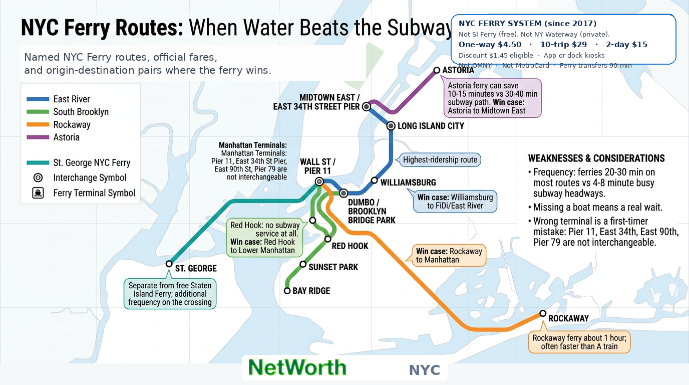
NYC Ferry charges a flat one-way fare of $4.50 on all routes (confirm current pricing on ferry.nyc). A 10-trip pass is $29, and an unlimited 2-day pass is $15 in the app. Eligible riders can use the Ferry Discount Program at $1.45 one-way. Tickets are sold in the NYC Ferry app and at dock kiosks. NYC Ferry does not use OMNY or MetroCard. Free transfers apply between NYC Ferry routes within 90 minutes.
The system runs several named routes, and each one serves a different part of the waterfront:
East River Route: Runs between Wall Street/Pier 11 in Lower Manhattan and DUMBO/Brooklyn Bridge Park in Brooklyn, with stops including Williamsburg and Long Island City in Queens. This is the highest-ridership route and the one that most New Yorkers know about. It serves neighborhoods where subway access to Manhattan is either indirect or requires connections.
South Brooklyn Route: Serves the Brooklyn waterfront neighborhoods further from the main subway lines — Bay Ridge, Sunset Park, Red Hook, and others. Red Hook in particular has no subway service at all, making the ferry its primary transit connection to the rest of the city.
Rockaway Route: Connects the Rockaways in Queens with Lower Manhattan. The trip takes about an hour, which sounds long until you compare it to the subway alternative, which requires the A train and runs significantly longer than that. For people traveling to or from Far Rockaway, the ferry is often faster and more comfortable.
Astoria Route: Connects Astoria, Queens with Midtown East Manhattan. Astoria to Midtown on the subway requires taking the N or W train and depending on connections can take 30-40 minutes. The ferry covers the East River section directly.
St. George, Staten Island Route (NYC Ferry): Separate from the Staten Island Ferry, this connects St. George to Lower Manhattan with a different schedule and some different stops. The Staten Island Ferry remains the free option and is generally preferred for cost, but the NYC Ferry provides additional frequency on this crossing.
When the Ferry Is Faster Than the Subway
The ferry wins on time for specific origin-destination pairs where the subway routing is indirect:
- Red Hook to Lower Manhattan: No subway serves Red Hook. The bus alternatives are slow. The ferry is the best option.
- Williamsburg to Lower Manhattan: The L train works but terminates at 8th Avenue in Manhattan. If your destination is in the Financial District or near the East River, the ferry to Pier 11 may be more direct.
- Astoria to Midtown East: Depending on where in Astoria and where in Midtown East, the ferry can save 10-15 minutes.
- Rockaway to Manhattan: The ferry is consistently faster than the A train for this corridor.
The ferry is slower than the subway for most Midtown-to-Midtown or local borough trips. It's a waterfront mode that specifically serves the areas where the subway network hasn't invested.
The Ferry Experience vs. the Subway
The functional difference is significant. A subway car on a crowded weekday morning is a specific kind of experience. The ferry provides an outdoor deck, views of the harbor and skyline, and a slower pace that some commuters value enough to take slightly longer trips.
The ferry is also less crowded than equivalent subway lines at peak hours. Service frequency is lower than the subway (ferries run every 20-30 minutes on most routes, compared to 4-8 minute headways on busy subway lines), so missing a boat means a real wait. This frequency gap is the ferry's main operational weakness.
Planning Around the Ferry Schedule
Unlike the subway, the ferry runs on a fixed schedule that you need to check before arriving at the terminal. The MTA real-time system tracks subway positions continuously; the ferry departs at specific times and won't wait. Missing a ferry by two minutes means waiting for the next one.
The NYC Ferry app and website publish schedules for each route. The NYC Live Command Center's Transportation panel also shows ferry status and scheduling information alongside MTA subway alerts, making it a convenient single place to check both transit modes before heading out.
What Most First-Time Riders Get Wrong
Two common mistakes on first ferry rides:
Arriving at the wrong terminal. Several Manhattan terminals exist (Pier 11, East 34th Street Pier, East 90th Street, Pier 79 on the West Side). Knowing which terminal your route uses before leaving is essential — these are not interchangeable walk-up stops the way subway stations are.
Not accounting for the weather. The open deck is pleasant in mild weather and miserable in rain or cold wind. The enclosed lower deck exists but fills up. Winter ferry commuters in New York are a self-selecting population of people who genuinely prefer it.
*The NYC Live Command Center's Transportation panel shows live MTA and NYC Ferry status alongside camera feeds across the five boroughs.*